Friday, April 4, 2014

Planning the Yukon's Most Energy Efficient Home

We are now less than a month away from starting construction on what we hope will be the Yukon's most energy efficient home.  It is a small laneway house that my wife Georgi and I are building in downtown Whitehorse to replace a very small, dilapidated "garden suite".  I'll try to post construction progress photos as the work progress, so check back soon. Here is what the building is going to look like:


Project Description: 704B Wood Street is a privately developed laneway house project. The project principals are based on bringing truly sustainable housing to the community.  The building is generally a "Craftsman" style home that draws upon architectural elements of  older homes and outbuildings in the neighborhood.  It is also shares the property with the Hulland House, a designated heritage home.  The new laneway house is designed to fit comfortably with the Hulland House and be a complimentary younger sister.

The house is designed to provide modest, yet high quality rental accommodation.  The house is a two-bedroom 970 ft2 suite over a single car garage and 480 ft2 unfinished basement. The building site is centrally located in downtown Whitehorse, Yukon and is an infill home on and existing lot. The building is designed with three major themes: Super energy efficient, Durable and Healthy.

Project Objective: To build a truly Sustainable home: A home that is an asset to future generations, not a liability. A Sustainable home project means:


Building Owner/Occupant
Building Team
Financially Sustainable
Affordable to own, operate & maintain (Simple, compact design; Energy efficient & Durable)
Financially successful project for team members.
Environmentally Sustainable
Reduced environmental impact of construction & operation (Energy efficient). Healthy for occupants.
Healthy & safe for building team during construction.
Socially Sustainable
·   Occupant: Lovable house, pride in ownership, dignity in housing, promote social interactions.
·   Community: Lovable house, contribute to the community and promote social interactions.
Happy Team: enjoyable project to work on; Pride in work & being part of a great project.

Key Themes:

1. Super Energy Efficient
Super insulated house; well-sealed.
Preliminary EnerGuide for Homes Rating: 88
Annual heating cost to be less than $300 / year.
2. Durable
Comprehensive Building Durability Plan. Building is planned to last for more than 100 years.
3. Healthy Indoor Environment
Ventilation plan & verification;
Use of healthy / low emission materials inside.


Demonstrating Sustainability: This project is registered with the Canada Green Building Council as part of the Leadership in Energy & Environmental Design (LEED)[1] for Homes Certification (CaGBC project #16524).   If achieved, this will be the second LEED Certified home in the Yukon.


[1] Leadership in Energy and Environmental Design or LEED is a consensus-based system for rating the design, construction, operation, and certification of the green buildings administered in Canada by the Canada Green Building Council

The “LEED Canada for Homes Logo” is a registered trademark owned by the Canada Green Building Council (CaGBC) and is used by permission. The logo signified that Old Way of Seeing Sustainable Building Services is actively participating in CaGBC’s LEED Canada for Homes Program; the CaGBC does not guarantee the products or services offered by its participants

Monday, December 2, 2013

Whitehorse Wasteland

Below is a map I made of all the "blank spaces" downtown.  All of the dead and wasted land downtown makes me crazy, yet we are developing new land.  In this map, all of the "white" areas represent undeveloped, vacant and underutilized land in downtown Whitehorse.  Obviously you can pick out the road network, but beyond that you can see a lot of white.  By comparison, look up in the residential area (west of 6th, far left of the map) and you can see how the downtown grid of Whitehorse should be filled out.

Pretty obvious we are wasting our downtown.  What do you think, maybe 20% of downtown not used adequately? Maybe time to do something about it.  Maybe it is time we start to move to land value taxation so we can at least start generating some revenue off of all that empty land.

Thursday, October 10, 2013

A tour of cycling infrastructure in Toronto

I've been in Toronto to see family and run in the Canadian orienteering championships in Hamilton this week.  Weather has been very nice, and so I decided to dig out my father in-law's bike which was abandoned in his basement and go for a ride (unfortunately, I didn't take my camera, so all of these pictures are shamelessly stolen from the internet).

I had a copy of the new Toronto cycling map and decided to take a route so I could check out the new "Cycle Track" on Sherbourne Street. I'll describe it a bit later on, but for those not familiar with it, a cycle track is a type of "bike lane"  that is somehow physically separated from the roadway.   It might be the premier type of bike infrastructure because it is fast and direct like a bike lane, but provides cyclists extra security and comfort by separating the bike lane from the car lane.  I noticed that when I was in Sweden this summer that this is the most common type of bike infrastructure there, even in the far north winter cities we visited.

Raised cycle track on Sherbourne Street, Toronto

Anyway, back to my route.  The first thing the struck me is the random, disconnected nature of the bike infrastructure - take a look at this map, do you see any logical routes or connectivity? 

Section of Toronto Cycling Map - random bits of bike infrastructure, not connected nor logical routes.  Blue lines are simply "recommended" streets to use and don't represent bike lanes or other infra.

Diminutive bike route signs
I started by following some of the blue routes, which are "shared roadways" that are supposed to be signed, on-street routes.  Well, there is signage, but it is tiny, and has route numbers on them that don't mean much to me.  Where does "18" lead me to?   Then the route was terrible, every intersection had stop signs, so no flow, stopping always - why could they have not just turned the signs?  And it was on rough, neglected streets!  I got lost a couple of times and had to check my map.  A one spot I even ended up on Bayview Extension (not a bike friendly place), looking up at a pedestrian overpass with on clue how to get up there.  A cyclists yelled down to me directions on how to get off the expressway and find the bridge!

Now, at this point I was pretty disappointed with how terrible cycling in Toronto is.  But then, I thought back to when I lived here in 2001, and back then there was NO bike maps, NO bike infrastructure, so I guess they actually have come a long way.  But, definitely the Car rules in Toronto.

Finally I made it to the Sherborne cycle track.  It runs north-south pretty much the length of downtown - so you can traverse downtown on separated bike route, which is quite nice (I've circled in in red on the map):

Sherbourne Street cycle track running the length of downtown north-south.

 It is pretty nice - fast and comfortable.   I found a little YouTube video of the track; it is of the upper part of the track which has a divider between the roadway and the cycle lane:


The upper section of the cycle track uses a low barrier to separate the roadway from the bike lane.

Cycle track with barrier type separation.

I don't know how well this would work in a winter city from a plowing perspective as it would have to be plowed separately, which is in fact what they do:
Plowing of Toronto cycle track

Raised cycle track with low roll-over curb.
Lower down on Sherbourne, the cycle track changes to a raised cycle track that is separated from the roadway with a low roll-over curb (shown below and as first picture above).  This type of track I think would work very well in Whitehorse because it could be plowed from the roadway with a wing-plow on the grader, but would keep all the road debris and snow-berm from the roadway out of the cycle lane.  If you look at the newly build Industrial Road, it has this type of low roll-over curb, so I know we can build them in Whitehorse!

Another thing I noticed was the abundant use of markings (paint/thermoplastic, etc), which  I'm always suspect of because in Whitehorse it always gets worn off in the winter.  But, then I remember that in low-traffic streets, the paint on our streets does last a long time.  I think we just lose the paint where there is a lot of motor vehicle traffic that tears the paint off when the streets are sanded.  So now that I think about it, I think the paint on a cycle track in Whitehorse would last pretty well.


Another neat thing was how the bus stops are integrated with the cycle track.  The track rises up so there is a good curb at the bus stop (there is also a good view of it at 0:35 in the video above):


After my fun ride down the cycle track, I then proceeded to get lost in the mayhem of downtown Toronto.  I think the car congestion in Toronto is worse than I ever remember it.  All the more reason this city needs to spend on getting people out of their cars.  

The rest of my ride was back to ratty old bike multi-use bike trails/paths up the Don Valley.  The trails are badly neglected, lots of pot holes, twisty and convoluted routes that go through parking lots, use road ways, etc.

I did get to ride along a new cycle path (two way) along Queen Quay which looks like is just getting finished and is obviously incomplete with a few gaps - it is a two-way shared pathway with laneway markings.  I didn't find any good pictures, but here is one earlier on in its construction:

http://www.ibiketo.ca/taxonomy/term/21?page=1
This trail/bikeway was nice, but the curbs at each driveway were very rough, so it made riding it a bit unpleasant.  Too bad, it would have been an easy thing to build t the curb cuts smooth so you could have a better ride. 

Anyway, the weather was amazingly nice for first week of October and so it was great to get out for a sunny, warm bike ride.

Saturday, September 28, 2013

Night Orienteering in the Yukon

Tonight was our last orienteering event of the year - Night Orienteering!  Personally, my highlight of our local season. 

Why?

Now for those who haven't thought about it too much, one might ask "what is so special about that, isn't it always dark up north?"

Think a bit harder....

When is orienteering season for us?  When there is no snow!

When is there no snow?  Summer!  Does it ever get dark in the summer in the north?  NO!  Remember, we are known as the Land of the Midnight Sun.

So, darkness and no snow is a very precious window for us, and so over the last few years we've tried to squeak in a night orienteering event when it starts getting dark, but before the snow comes.  Actually, our first night-O event four years ago (at Yukon College map, thanks Bob for starting this up!) did have snow, but we've had lucky late-Septembers since then.

This year we squeaked in one last event.  The meet organizers figured it would only be the "hard-core" orienteers that might come out, so the decided to plan the race down on the Lorne Mountain map, about 40km south of Whitehorse.  This is the same map area that Yukon Orienteering hosted the 2011 Canadian Sprint Orienteering Championships if anyone remembers.  Typically, this map is "too far out of town" for our mainstream members, so we don't get a lot of use of it.    So this made it a double-treat: night orienteering on a super sweet, high-speed open forest map we don't get to run on very often.

Here's how it went down:

Waiting around for it to get dark.  Note Afan's washing machine drum-mobile fire pit - a life saver on a late September Yukon night!
The Boys are Back in Town - Caelen and Leif!

Leif figured mounting a car light on his head was a good idea.  Unfortunately, he forgot to fully charge it before the race.
Loading up control descriptions and getting ready to go!
Excellent - Sprint map in the nice stuff!  Parts of the Robinson Roadhouse map used for the 2011 COC Sprint.

Ah, this is what we are looking for - the night time flash of the control.
In reality, with a narrow-beam super headlamp this is what it looks like.  See the flash and run like heck towards it.
Afterwords, looking happy to have made it back.  A close race, everyone in the 20's minute range!  Ross, Erik and Caelen.


Figurin' where the race was won and lost afterwords.  Katherine and new baby in background.


Pretty damn fun!  Thanks Afan for being the event planner - a fun end to the season!

Thursday, September 26, 2013

Problem intersections in Whitehorse

The City of Whitehorse has recently embarked on a "Transportation Demand Management" study.  Which is basically a fancy way of saying "how do we get better at getting out of our 1-ton death machines and start enjoying our community more?"

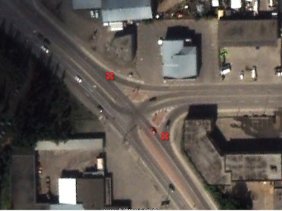
As part of this, the City and their consultant solicited a list of "problem" locations which pose problems/barriers for cyclists.   When I looked at the list of issue points on the roadways, what I realized is there is a particular type of intersection in Whitehorse that is causing problems:  it is the triad type intersection that incorporates separated diverge/ merge lanes.  Examples of this include Lewes Blvd+Hospital Rd., 2nd+RSW, 4th+2nd, 2nd+Quartz and 2MileHill+Industrial

Right turn merge/diverge lanes that cause conflicts with cyclists.  Example shows 2nd and 4th Ave. intersection with red "X" showing conflict points for rapidly right-turning motorists.  Do we REALLY need these "express" lanes?
The problem with these intersections is rapidly right turning motorists, which cause a cycle/auto conflict.  Do we REALLY need merge/diverge express lanes at these locations in this town?  Let's be honest: No. 

We can all slow down and execute a normal right-hand turn with a slowed, shoulder/mirror check for a cyclist, then proceed with a normal right-hand turn as per almost all other intersections.  Will gridlock and traffic chaos erupt?  No.

What I realize is ultimately when these intersections get re-built, they should get rebuilt as normal T-intersections (multi-lanes okay) which will result in a safer environmental for all of us, including when we drive our cars.