Friday, May 31, 2024

Waterfront Rail Trail

 The Riverfront Multi-Use trail is the backbone of Whitehorse's active transportation.  It is highly popular with everyone in Whitehorse for walking, running and biking, year round.  It was originally built as a recreation facility and not intended for people's daily commuting.  But with its success, and the rise of bike commuting, ebikes and cargo bikes, the Riverfront Trail is starting to get crowded at times.  And there are conflicts between people out for a sunny stroll and those who are just trying to get to work or school on time.  

What we need is more capacity on the Riverfront Trail.

The solution lies right next to the Riverfront Trail:  the abandoned White Pass & Yukon Railway line along the riverfront!   

Let's celebrate Whitehorse's railway heritage by converting this abandoned line to a bike path, running from Quartz Road (near the grader station) in the north, extending (one day) 3 km to Robert Service Way in the south. 

This could provide a bike commuter route for people who want to get places, thus avoiding the recreational walkers and rollers on the Riverfront Trail.  And it would create some key missing connections:  connections from the Riverfront/Waterfront trail to the future bike routes on Wood and Black Street (both of which are school streets).

Wood Street Connection at Roundhouse:

Black Street Connection at Kwanlin Dun Cultural Centre & Library:

The exciting thing is a couple hundred meters of the rail trail already exists - the paved section in front of KDCC and the Library!


Slap a bit of paint on Front Street and that would be a start.  Building this short segment from Keish to Strickland would be great just on its own for a connection to Black Street / Whitehorse Elementary & the KDCC/Library to Riverfront Trail:

 
I know there is some ideas out there of running the trolley.  But that is just from the Roundhouse, south.  North of the roundhouse, the track has been partially removed, paved over and the whole thing north is abandoned.  So we could at least build the 2 km of rail trail north to Chilkoot & Quartz/grader station.  Even this would be a great addition to the active transportation network and create key linkages; a "fast route" to reduce conflicts.

I would be okay if this is not maintained in winter and the City just do a good job on winter maintenance of the Riverfront Trail.  If one day the Riverfront Trail gets too busy in winter too, then that would be a good problem to have.  


Sunday, March 3, 2024

One Year Carbon Neutral

With all the talk of "Net Zero" and "Carbon Neutral", I was curious if our family could be carbon neutral*.  So I started tracking all our greenhouse gas emissions, including gas for the cars, propane for the stove&bbq, electricity (using monthly average emission factors from Yukon Energy) and flying.  

Then, using the money we get back from the carbon rebate (which is currently $372/year, or $279/quarter for our family of 3) to buy carbon offsets each quarter to make us carbon neutral. And the money from the rebate was more than enough to cover the cost of buying offsets.  So effectively, it cost us nothing to go carbon neutral.  

Here is how 2023 looked: 

Buying offsets is always the last resort.  First is to reduce as much as possible.  Locally, we drive very little and thankfully, our electricity in Yukon is very clean (in 2023 Yukon's grid was 90% renewable, so a bit lower than average).  As you can see, our biggest part of our carbon footprint was flying as we had a number of trips outside in 2023.  For context on the chart above, I included the per-capita non-mining emissions for three people.  This data is from 2021 since Yukon Government lags two years in publishing the annual greenhouse gas emissions report.  This is not totally a fair comparison, because it is more than just household emissions, but also includes all of Yukon's emissions, including business and government.  

With respect to buying offsets, that is a bit of a wild west and totally buyer beware.  I choose a Canadian company, Planetair, and selected their Planetair Canada-Trees Portfolio.  I choose this offset because the offsets are in Canada (I have a bit more confidence than international offsets), it is Gold Standard certified, and it includes additional tree planting as part of it.  I figure the tree planting will help create actual removals in addition to the offsets.  Who knows, but one just needs to do their homework and do their best.  This offset costs $30/tonne, and thus we paid $468 in offsets total.  Note we got $1,116 in carbon rebates, so we are still ahead. 

So my conclusion is being carbon neutral is totally do-able.  I think we'll keep doing it.


*carbon neutral is different than net-zero, see https://www.sustain.life/blog/difference-between-net-zero-carbon-neutral for a good discussion of the distinction.

Thursday, January 18, 2024

2023 - A Year of Bike Infrastructure

Although we like to complain about the lack of adequate safe and connected year-round cycling infrastructure in Whitehorse, 2023 did see a number of projects big(ish) and small that really make it a landmark year for cycling infrastructure.  Here is my list to top-10 bike projects of 2023:

10. Shark-Teeth at Industrial Rd & Two Mile Hill Intersection

This is pretty minor, but the first use of painted "shark teeth" in Yukon: it is to show drivers they need to yield to bikes and pedestrians.  It is a common marking used in Netherlands to show who needs to yield.  Will it make much of a difference here?  Probably not, but nice to see and hopefully this will become the common standard combined with a move to protected intersections (there is a real dutch-style protected intersection in Canmore that is pretty interesting to check out - maybe we too can be this progressive).

9. 1,000 E-bike Rebates

Okay, I had to stretch to make 10 items on my list, but I still think this is notable.  Government of Yukon this autumn announced they had issued over 1,000 e-bike rebates.  Yukon has, as far as I know, the most progressive e-bike rebate program in Canada.  I have heard it is Yukon's most successful climate-action inventive program to date, far exceeding the EV rebates.  With 1,000 e-bike rebates, that means there is about one e-bike for every 10 households in Whitehorse.  Wow!  That will drive the need for year-round bike infrastructure that is e-bike suitable.  

8.  Buffered Painted Bike Lanes on Lewes Blvd 

This one is just paint, so not much to get too excited about (and we all know on-street bike lanes don't work in winter), but it is nice to see more space being created for bikes (goodness knows our streets have more than enough space!) 
 
The painted bike lanes are now officially designated on Lewes Blvd and widened to 1.8 m, plus a 0.3+ m buffer.  Unfortunately, YG's line painting crew did the painting, so they are wobbly and confusing as heck.  Hopefully they will get re-painted next year and get more established with time. This 1 km of bike lane, combined with the buffered bike lanes on Quartz Rd. and short section on 4th Ave bring a total of modern-width buffered bike lanes to 2.2 km.  

New buffered painted bike lanes on Lewes Blvd.  Note old lines so you can see how the lane has been widened.  Also note the sign, which officially designates this as a bike lane.

7. Track Removals 

This is bit of small, sleeper project, but again a step in the right direction.  The City quietly removed the northern two set of track crossing on the Waterfront Trail.  This reduced hazards and increases accessibility.  I've heard from some e-bike riders that this really made a difference because these were really rough for the bigger/heavier bike. Two track crossing down, only 8 more to go (counting trail-access points.) 


6. Lewes Blvd & Alsek Rd. Intersection

Some improvements were made to the intersection at Lewes Blvd and Alsek Rd. in Riverdale as part of a Yukon Government drainage improvement project for the intersection.  Sadly, it seems the City and cycling community was not involved until too late on this project, so its full potential was not realized and the dangerous"pork chop" was retained.  However, there are some good, and some "interesting" things:
  • Quasi-protected island the south side crossing of Lewes Blvd for kids walking to school.  This included narrowing the crossing distance.
  • Ride-through cuts on the pork-chop so you don't have to ride up-and-over the island
  • A sweet bike on-ramp from west-bound Alsek to the north-bound multi-use trail on Lewes Blvd.
  • An odd ride-up ramp that direct north-bound cyclists on the bike lane through the intersection and onto the multi-use path.  Certainly it makes getting to the path easier with less chicane, but I know folks are worried about pedestrian conflicts.  

So, overall, and improvement, but again, a project falling short of its potential because cyclists were involved too late in the project. 


Ride-through cut-outs on pork-chop island.

Sweet bike path "on-ramp" from Alsek Rd.

5. Raised Intersection on Two Mile Hill & Canadian Tire

Another small project - the City originally had this designed in 2018 and only took 5 years to get built!  It is straightening out of the silly intersections along 2-Mile Hill.  This one being the north entrance of Canadian Tire:  the trail was straightened and the intersection raised so the bike path goes straight through.  The idea is to show cars that bikes & pedestrians have the right of way (note the stop sign is behind the crossing).  I think the raised "hump" is too smooth for cars to really notice.  The raised intersection at Black St. & 7th is a better example.  

This upgrade also starts to implement some Protected Intersection design elements such tightening the curb radius and keeping the bike path back from the intersection to create a "yield-zone" between the parallel roadway and the path crossing (in this case, only about 4 m).  This gives drivers a space to yield if they make a mistake and don't see a bike coming.  These elements aim to slow down cars through the crossing, and thus reduce the consequences of mistakes (because as humans, we all make mistakes.)

None the less, nice to finally see this done.  One crappy intersection down, only 5 more to go on the Two-Mile Hill path.   


4. Completing Range Rd South Multi-Use Path

A project of epic duration!  Yukon Government started the muti-use path along Range Road south back in 2019, building just the south half, then abandoning the remainder, leaving it unfinished.  The City picked up the work in 2021, had it extended northward some, but then were delayed two years completing it due to a conflicting lift-station project.  Then, hallelujah, in late 2023, the path was finished!  It is almost 900 m of new multi-use path that consists of a cool Y-shaped split that connects northward along the Alaska Highway as well as continues along Range Road to Two-Mile Hill.  It included narrowing the entrances to Canada Post by a bit to make the crossings safer for bikes.  

A notable feature is this path included planning for drainage - it is elevated and has ditching on both sides - a first for a multi-use path in Whitehorse!

I quite like the western leg that goes along the Alaska Highway because it winds through the trees near Canada Post.   This City has been doing a great job of maintaining this path through the winter, so it is great to finally have a safe, year-round connection along Range Road south all the way to the Airport path and Hillcrest. 


Path split, looking northward.  To the left continues along the Alaska Highway.  I took this picture just as they were wrapping up paving of the remaining northward leg on Range Road, hence the barrier.  It is now open.

Nice view of the drainage considerations give to this trail.  Note in distance the "after-the-fact" trail connection to the City's own Operations Building that was originally forgotten.  Oops.  (Photo credit: Sheryl Polachic)

 3. Removal of the Deathly Boardwalk

This again is a small, simple project that has taken almost a decade to get completed: removal of the deadly wooden decking crossing the tracks on the Waterfront Trail behind Yukon Government main administration building.  There have been enumerable cyclists accidents on this wooden decking that got slick in the autumn, including several hospitalizations and broken bones.  This had being going on for years, Yukon Government was fully aware of it and did nothing meaningful to protect people's safety. It finally took a meeting with the Minister of Highways and Public Works to weigh in and get this dangerous section of trail fixed.  

For some unknown reason, the tracks were left in place and the trail retains the ridiculous chicane through this section.  Again, project expenditure that falls short of the opportunity because cyclists were not involved in the solution.

Wooden decking replaced with asphalt.  Strangely, YG forgot to take out the tracks, so some hazard remains. (Photo credit: Lewis Rifkind)

2. Alaska Highway South Multi-Use Path

The 2.6 km extension of the of the paved multi-use path from the airport to Robert Service Way has at least been one positive outcome from the millions spent on Alaska Highway widening project.  Although I would not have put this project on my "priority" list, I must confess it is a real pleasure to ride.  It is surprising how much quiet it along the path, even though it is just adjacent the highway.  And it is so nice as a recreational riding linkage that you can now ride all the way from Robert Service Way to Two Mile Hill, a 5.8 km distance, totally separated from road traffic.

As nice as it is, it does fall just short of meeting the All Ages and Abilities standard due to some excessively steep grades, unnecessary hills (although not much of a problem) and lack of Protected Intersections.   It also suffered from drainage problems (a highway culvert dumps its water on the path, washing out the path) and a dead-end at the Robert Service Way pork-chop.  This last problem was quickly rectified thankfully.  

Overall, an unexpectedly pleasant addition to the active transportation network in Whitehorse.  


Ill planned drainage woes.  Even though the lower culvert has been installed, the water is still running down the west side and washing out the trail further down.  It will be interesting to see what happens this spring.

Location of the initial embarrassing "dead-end" at the south end of the path that was posthumously, but promptly, fixed.

1. Chilkoot Way Cycle Track

#1 on on my 2023 new bike infrastructure list, love it or hate it, is the new, longly awaited Chilkoot Way cycle track*.   This project, known by some as "The Gap," was identified as one of the top priority projects during consultation on the development of the City's 2018 Bicycle Network Plan.  Then late 2019 a delegation of youth petitioned City Council to give them a safe way to bike to school, and their petition garnered over 2000 signatures.

The City subsequently proposed a fully separated, multi-use path along Chilkoot Way between the Waterfront Trail (Quartz Rd.) and Two Mile Hill.  There were several potential routing option, with many commuters from up the hill preferring a more separated route passing behind Canadian Tire & Walmart which would avoid the multiple intersection crossings.  On the flip-side, a route on Chilkoot Way provided greater network connectivity as it links to the crossing lights on Two-Mile Hill and Quartz Road, enabling connections to the rest of downtown.  And although not as good for through-commuters, the Chilkoot Way route provides connectivity to amenities such as the grocery store and post office.  There is no one-best solution, and in my view, we should have both routes one day.

Unfortunately, several years passed with nothing getting done on this project, including the City missing the opportunity for 100% federal funding to build this during the pandemic years.  The years slipped away and those kids who just wanted a safe way to bike to school grew up and became drivers. The City finally decided to do a "quick build" pilot project so they could get something built in 2023.  

I use quotes around "Quick-Build" as it turned out to be anything but quickly built. The City is at the mercy of the contracting industry and because of the current demand have a hard time even getting bids on such projects.  The cycle lane got build in stages with the paint going down in early August, but no barriers or signs till the winter (barriers put in October, signage finally put up in November!)  As of this time, the project remain unfinished with the curb cuts remaining to be done, including fixing the awkward to/from the Two Mile Hill bike path.  This caused no end of confusion and controversy.  It even sparked bikelash with a small petition and delegation to Council asking for the bikes lanes to be removed.  Thankfully, Council did the right thing, with they Mayor making some statements:

"What we're doing here on Chilkoot Way is happening all over the country, has happened in Europe for years and years and years," Cabott said. "So it is new to the city of Whitehorse and the residents and I accept that... Change can be difficult and we want to try and implement this in a way that works for people, but this is the way of the future." (Yukon News, Sept. 26, 2023)

The bi-directional cycle track is new to the Yukon, but has been used extensively elsewhere in Canada.  The Chilkoot Way design conforms with what is typically done for these facilities.  But you do need to use it with your heads up as there are multiple conflict points and motorists do not expect bikes coming from two directions, which is one of the problems with these bi-directional facilities. 

So this important link is not without controversy.  It is not how I would have to have seen it done, but I am happy there is something there.  You do have use it with caution, watching for traffic, but it is certainly better than riding on the road unprotected.  And in winter, it has been clean and beautiful, generally free of snirt.  And from the tracks I see, it does seem to be getting heavy usage all winter long. 

By mid-November, signage and barriers were finally in place.

Just hours after a snowfall, the cycle-track is already plowed and there are numerous bike tracks.  Looks like someone is using it!

* a cycle track is a on-street bike lane that is physically separated from traffic.


New Year Bonus:  Winter Maintenance to Hamilton Blvd Trail and All Season Access to Canada Games Centre

To start off 2024 on a good note,  have a bonus time to add to the list: winter maintenance of the Hamilton Blvd motorized multi-use trail.  This 4.6 km trail that runs from the Alaska Highway, provides active transportation access to the Canada Games Centre is the only trail serving over 25% of Whitehorse's population.  This trail provides access for motorized recreationalists to Whitehorse motorized trail network.  The City has relied on volunteer labour of the Klondike Snowmobile Association to maintain the trail in the winter, but historically they have just packed the trails for snow machines and thus it was not usable by other uses.

In winter 2022/23 the City demonstrated they have the ability to do winter multi-use trail maintenance that is usable by all users, including snowmachines.  This means leaving a bit of packed snow base and not graveling the trail.  Ironically, this actually results in a better winter surface for biking too.

Based on this success, Whitehorse Urban Cycling Coalition, Cycling Association of Yukon and Klondike Snowmobile Association developed an interim winter maintenance proposal and delivered this solution to the City.  It calls for the City to maintain the Hamilton Blvd trail by plowing, but leaving packed snow so both snowmachines and active transportation users can both use the trail.  In the 2023 operating budget the City got additional funding for winter maintenance and thus we are waiting for the City to fully take on this service.   In the meantime, KSA has stepped up to backstop the City, to the best of their ability, to plow the trail.  To date, thanks to their volunteer effort, the trail has been in very good shape and is regularly usable for all winter users.

The exciting this is this year is the first year in 18-year history of the Canada Game Centre facility that it has been accessible in winter by active transportation.  Since the accessible winter maintenance has started this winter, there has been a significant increase in walkers and cyclists using the path in winter.


Sunday, November 19, 2023

Whitehorse's Rail Trails

Many dream of the day when the White Pass & Yukon Route tracks through to Carcross can be converted to a multi-use rail trail.  At least let's get the Riverfront Railtrail through downtown built!  Rail trails are abandoned railways that are converted to recreational and active commuter trails.  They are wonderful.

But I realized there are already a number of "rail trails" in Whitehorse already.  Here is a map of the intermittent pieces and a description of each of them: 

1. White Pass & Yukon Route

Two short sections of abandoned rail grade have had the track removed and can be used for biking and walking (shown in yellow on the map)

  1. Utah - this is my favorite piece of rail trail. It is a 1.5 km long piece extending south from Miles Canyon Road with great views of Miles Canyon and a convenient connection south to the American Laundry road at MacRae.  It was abandoned in the 1960's because of a landslide as the land moved down towards the Yukon River just upstream of the canyon.  The track was rerouted further west closer to the highway where it is today.  
  2. Marwell Spur - the railway was extended from downtown northward to service the building of the refinery in Marwell during the war.  The old railway grade makes a nice path along the river, extending north from Chikoot Way to behind the grader station, where it dead-ends at a fence.  The tracks used to extend a bit further, but that lies on the North 60 Petro property now.  600 m of it are accessible today.

2. Macauley Tramway

This is probably the oldest "rail trail" in Whitehorse and is remnants of the horse drawn log-tramway that portaged boats around Miles Canyon and the White Horse Rapids.  Parallel "humps" where the log rails were can be see today bordering the trail.  It remains in two portions (shown in green on the map), with the middle section submerged under Schwatka Lake when the dam was built:
  1. South Portion - extending 2.5 km from Canyon City in the south to where it dives under the lake at the north end near the Sckwatka Lake boat launch.  Today it is used as the Red and portions of the Yellow ski trail as part of the Chadburn Lake ski trail network.
  2. North Portion - extending 2.1 km from the dam to almost the Robert Campbell bridge in Riverdale (behind FH Collins).  Much of this section has been paved over for the Millennium Trail, but at the northern end, in the forest behind the school, the straight alignment with twin rail-humps can still be found

3. Hepburn Tramway

This is the second gold rush era tramway, but built on the west side of the river.  Not many people know about this trail, although the Yukon River Trail Marathon route follows the north end of it as a "goat trail" cut into the hillside above Miles Canyon and Schwatka Lake.  The route is well documented by Peter Long in his publication  Forgotten Trails, walking the Hepburn Tramway  (and thanks to Peter for providing the mapping data.)
 
About 4.2 km of this tramway can be followed (shown on red on the map), although only the the southern part can be mountain biked, where the rest is mostly a footpath and does require some scrabbling at points.   

4. Copper Mines Branch

This is the longest "rail trail" in Whitehorse, and is an abandoned 18 km long branch line (shown in orange on the map) that was built to service the Whitehorse Copper Belt.  During the 1960's era mining of the copper belt, most of the rail grade was re-built as the Copper Haul Road.  Knowing this was once a rail grade explains its gentle grades and broad curves.  
 
The Copper Mines Branch has been well documented recently in Eric Johnson's 2017 book "Copper Mines Branch:  White Pass Rails to the Whitehorse Copper Belt" and on Tim Green's website: https://then.timmit.ca/projects/cmbranch/index.shtml.
 
  1. South portion - 750 m piece of trail in the Whitehorse Copper subdivision.  The start of the branch in occupied by private property, but you can get on the public portion at Esker Dr and follow it till it runs into the fence of an industrial property.  There is some interpretative signage is found here.  
  2. Middle-south portion - another 500 m segment of the rail grade can be found north of the industrial properties off of Collins Lane.  It is a bit hard to get to, but interesting.  Sadly, it is a dead end to the north where the bridges crossing the lakes and swamps are gone.  But fun to find the old bridge abutments
  3. North portion - 12.3 km of "rail trail", now mostly the Copper Haul Road extending from the Whitehorse Copper mine north to reach almost to the former Peublo Mine (now Icy Waters fish farm) on the Fish Lake Road.  Most of this route is a road, but there are two short sections of the old railway grade that can be found along the way. 

 Here are my pictures from running the length of the Copper Branch with by friend Brent a couple of years ago: Copper Mines Branch 

Enjoy!


Wednesday, February 1, 2023

Riding from Whistle Bend

I've been hearing a lot of discussion about riding to/from Whistle Bend, plus perception of traffic problems with getting from Whistle Bend.  So, I put some thought on what might be the best way to get there if we wanted to invest in active transportation infrastructure so people can get between downtown and Whistle Bend safely and comfortably by bike, or better yet, by e-bike!

I don't live in Whistle Bend, nor do I bike there often, so I really don't know much.  But hey, lack of knowledge has never stopped people from expressing their opinion on the Internet!  So here we go...

Routes:

I looked at four routes to/from Whistle Bend to a common point to downtown.  To make a fair comparison, I chose the top of 2-Mile Hill (as opposed to going down Mt.View Drive/Copper Rd., you will see why).  The image below shows the routes, plus the distance and total climb if riding south from Whistle Bend to 2-Mile Hill.  These routes are:

  • Route C: McIntyre Creek - assume a protected path up Whistle Bend Way to the roundabout, then a paved multi-use path connecting along the powerline/waterline to the Porter Creek trail crossing McIntyre Creek.  I assumed the path would be optimized south of there to avoid the gratuitous  hill to Takhini, instead following the natural, less hilly route along University Drive to Takhini.
  • Route M: Mountain View Drive - similar to Route C, assume a protected path up Whistle Bend Way to the roundabout, then a separated, protected path along east side Mountain View all the way to Range Rd.*  From there, following the protected cycleway along Range Rd to 2 Mile Hill.
  • Route D: Direct Route - this is the creative route: build a direct, paved, lit, multi-use path linking Range Road at Whistle Bend to Mountain View Drive, thereby avoiding the hill with a nice gentle downhill through the forest!  Then follow a separated, protected path along east side Mountain View all the way to Range Rd.*  From there, following the protected cycleway along Range Rd to 2 Mile Hill.
  • Route R: Range Road - assume a protected path built along the west side of Range Road, all the way to its crossing of Mountain View Drive*.  From there, following the protected cycleway along Range Rd to 2 Mile Hill.

All of these routes involved building new, separated protected safe, all-ages and abilities accessible infrastructure to make choosing cycling comfortable and convenient.   The difference is both the distance, but more importantly for riding a bike, the climb!  Hills, especially in winters, are the major barrier to active transportation. 

Results:

What do we see? Well, my so-called "Direct Route" is shortest by almost half a kilometer, but most importantly, it has over 40% less climb.  That is a lot!  29 m of climb vs. about 50m of climb for all the other three options.

  • Route C: McIntyre Creek - 4.9 km - 51 m climb
  • Route V: Mountain View Drive - 4.5 km - 52 m climb
  • Route D: Direct - 4.1 km - 29 m climb
  • Route R: Range Rd. - 4.6 km - 50 m climb

Below are climb profiles of the four routes, starting at Whistle Bend and finishing at 2 Mile Hill.  Note the vertical scale is not the same in all of these:

Route V: Mountain View Drive elevation profile

Route C: McIntyre Creek route elevation profile

Route D: Direct route elevation profile

Route R: Range Road elevation profile


* Here is a bonus idea:  the north side of the Range Road and Mountain View Drive intersection is a natural place for an active transportation underpass.  The reason is the topography is naturally suited for creating the separation.  Thus you could ride north from Takhini to Range Point or Whistle Bend, or even Porter Creek without having to cross Mountain View Drive!  Even north-bound bus users would benefit because they could access the University without having to cross and stop busy traffic on Mountain View.  

The other cool thing I learned recently is underpasses are better than overpasses for cycling because you carry your momentum, thus getting you half way up the other side without effort.  Physics! 


Sunday, December 19, 2021

Cycling Project Pipeline for Whitehorse

 For a number of years I have been saying we need a "project pipeline" for building the cycling network in Whitehorse.  What  I mean by a "project pipeline" is a orderly plan and schedule for building the connected, convenient and logical cycling network.  Building these projects takes time, especially to be planned and designed well.  It takes a year or two just to plan and design before the projects can get built, thus it is important the planning is done in advance and so the projects ready to go.  

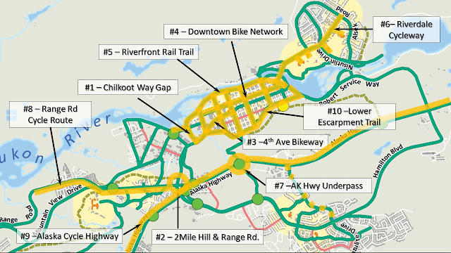
The following is 10 Big Projects I dreamed up for what might be a good pipeline of projects to get built.  No schedule here, just my idea for a general order of priority:

  1. Close the Gap - Chilkoot Way cycling (MUP) connection from 2-Mile Hill to Waterfront Trail
  2. Active Transportation re-build of Range Road & 2-Mile Hill intersection - but design it well this time with a Protected Intersection approach. 
  3. Re-build 4th Ave Protected Bikeway - from Black Street to 2nd Ave (include re-build 2nd and 4th intersection to improve accessibility and safety).
  4. Complete the Downtown Bike Network - in particular the protected cycle infrastructure on the cross streets of Hanson, Wood, Black, Ogilvie and 2nd Ave (4th to Waterfront trail).  This would be a big, multi-million dollar project that will be well suited for federal funding (such as Canada's Active Transportation Fund).  Also connect the two downtown schools to the bike network.
  5. Build the Riverfront Rail Trail - convert the railway tracks to a cycling rail trail - to create more capacity along the waterfront, reducing conflict with pedestrians.
  6. Riverdale Cycleway - Complete a contiguous, convenient protected bike route the entire length of Lewes Boulevard, complete with high quality, convenient connections to the 6 schools along the route. 
  7. Alaska Highway underpass - create a safe crossing from the north end of the airport to the west side of the highway.  I've written about this underpass before, you an read more here.
  8. Range Road cycle route - including underpass of Mountain View drive at Range Road to provide a safe, separated connection from Range Road north to Takhini and Yukon University. 
  9. Complete the Alaska Cycle Highway - a separated, protected bike route the length of the Alaska Highway through Whitehorse - from Carcross Corner to Whitehorse's northern city limit at the Mayo Road.  Consider another underpass from Takhini North to Kopper King, providing a safe crossing for Kopper King residents and access to the Mt. Mac ski trails and greenspace. 
  10. Complete Lower Escarpment Trail - finish the downtown active transportation loop.  Consider an underpass of Robert Service Way at 5th Ave so there is a separated, convenient safe way for people to access the Millennium Trail without have to cross traffic.

In parallel, Hillcrest re-construction should be occurring which should build the bike network from Alaska Highway up to Granger/Copper Ridge.


Saturday, July 31, 2021

Exploring the Old Alaska Highway - Off-Highway Ride from Whitehorse to Haines Junction

Summary:

  • Ride the route of the original Alaska Highway between Whitehorse and Haines Junction
  • 160km total distance, 90 km are off the modern day highway
  • Can be a nice one or two-night trip (Friday evening, Saturday & Sunday)
  • Mix of highway pavement, backroad pavement, gravel and some interesting abandoned paved sections in the forest.
  • Day 2 is particularly nice with last 35 km from Canyon to Haines Junction completely off-road with some really nice gravel riding.    

The Idea:

I realized that much of the original route of the Alaska Highway between Whitehorse and Haines Junction still exists.  So we found and followed much of it on our bikes and were able to ride about 60%, or about 90 km of the 160 km between the two towns off of the modern day highway.  We ended up finding some pretty interest and nice gravel riding, a great way to make the trip.  Some of it is well known, such as "Old Alaska Highway" near Whitehorse, or the section through Champaign, but others are either pretty overgrown, or, nice gravel road such as the section of the route that follows the Kluane Wagon Road from Canyon into Haines Junction.

I'm not keen on camping, so I try to find accommodation along the way.  We left town Friday after work and stayed at Muktuk Adventures (lots of great accommodation options here, plus great breakfast!).  I couldn't find accommodation half way, so ended up leaving our trailer at a friend's place at Mendenhall, but post-pandemic it might be possible to camp/stay at Long Ago People's Place, which would be pretty cool.  I haven't talked to them yet, but it would be worth following up next year. 

Here is the 1946 airphoto and you can see how it weaves across to the west where Birch St is now, then back over to Centennial St north.
 

Route Overview:

You can do this route as an overnight, riding about 80 km each day.  But we did it as a 2 1/2 day trip (two night) leaving town Friday afternoon, then two full-day rides Saturday & Sunday.

 Download the route for Ride With GPS: https://ridewithgps.com/routes/36322813

Day 0 - Whitehorse to Old Alaska Highway / Muktuk Adventures - km 1430 to 1442

From downtown, ride about 26 kilometers of the Alaska Highway, then about 4 km off the highway to stay overnight at Muktuk Adventure's cabins. 

  1. Centennial Rd. in Porter Creek is the old Alaska Highway route.
    We started following the old Alaska Highway from Porter Creek where Centennial Road follows the original route of the highway.
  2. Cross to the west side of Alaska Highway at Super-A where Birch St follows the route of the original highway. 
  3. Cross back to Centennial at Wann Road and follow it to MacDonald Road.  We stopped for dinner and a beer at Whiskey Jacks
  4. A few kilometres on the highway past Crestview and there is a 1 km section of gravel road which is the old highway on the east side before Cousins Airstrip.  You can stay off the highway by continuing through the rest stop and follow the ATV trail on the east side to the intersection with the North Klondike Highway.
  5. Cross the N. Klondike Highway to follow ATV trail on the east side of the highway, climb the hill to access a nice 3 km section of the old Highway, which is now Parent Lane.  
  6. At km 1441 cross to the south side of the highway to find two short loops of the old highway and are now Echo Lake Road and Jackson Road.


Day 1 - Old Alaska Highway to Mendenhall / Champagne - km 1442 to 1496/~1508 +/-

The first full day starts with a nice ride on the paved Old Alaska Highway just outside Whitehorse, a few abandoned sections before Takhini Crossing, and then the longest on-highway stretch - about 28 on highway before you find the next abandoned segment near Stoney Creek.  The old section of highway through Champagne is about the half-way point of the trip, so find camping in this area:

  1. Old Alaska Highway is a 6 km side road which makes for a nice morning ride to start the day.  Feels very rural.
  2. Between here and Woodland Road (km 1453) are three short segments on both sides of the road that are quite overgrown, but ridable on a mountain or gravel bike with hearty tires.  
    Woodland Rd., last section of old highway for a while.
  3. Woodland Road is the last section of old highway for a while, so it is worth riding.  A bit of a scramble back down to the highway at Takhini Crossing.  
  4. After 28 km of mind-numbing road riding (stop to admire the cows and have lunch at the Takhini River to break up the monotony), you again find sections of old highway on the south side - a very short segment at Annie Ned Creek and then a longer section starting at km 1483 just before La Prairie ranch.  
  5. At km 1484 you can follow the old highway on the north side where it crosses Stoney Creek.  The bridge is gone, so you'll have to go back to the modern highway to cross the creek, unless you are an obsessive person like me with a partner of infinite patience and insist on wading the creek and bushwacking back up to the old road route. 
    Crossing Stoney Cr., not remains of bridge on far bank.
  6. At km 1488 you can find an old piece of road on the south side that leads to the Kusawa Lake road.  It  has been "scarified" so is pretty rough to ride, but you can see a bit of yellow line still on the broken up chip seal.   
    Remains of yellow centreline along abandoned section of old highway near Kusawa Lake Rd.

    You can detour down the Kusawa Rd for a couple of kilometres to reach the Mendenhall River crossing which is a good place to take a swim and cool off. 
  7. After crossing the Kusawa Road, cross to the north side of the highway to find another <1km section of old road, better riding this time.
    Old asphalt at km ~ 1490, north side of the modern highway.

  8. Now another 5 km on the highway before reaching the Mendenhall Subdivision access road which is another 1.5 km chunk of the old highway you can ride through.

We stayed the night at a friend's property at Mendenhall, so depending on where you camp adjust your day 1->2 break.


Day 2 - Mendenhall / Champagne to Haines Junction - km 1496/~1508 +/- to km 1578

 Day 2 is the better day with lots off-highway riding and some interesting discoveries.  The longest "on-highway" stretch is about 14 km from the west end of the Champagne road to just before Cracker Creek.  From Cracker Creek onward, the route get fabulous with fun abandoned paved sections to the fast gravel ride on the Kluane Wagon Road / Marshall Cr. road for the last 35 km of the route:

  1. After the Mendenhall section, cross to the south side of the highway at km 1497 to avoid the big hill.  This takes you on a gravel trail through a really nice grassland that is worth the detour.  
    Trail through nice south-facing grasslands allow you to bypass the big hill after Mendenhall

  2. About a kilometer and a half later, you can cross the the north side of the highway for a nice three km gravel section of the old highway (starts at km 1500)
  3. After crossing the Mendenhall River you get to the old highway Champagne.  This is a leisurely 14 km paved road with very little traffic, and of course the highlight is the history-rich village of Champagne.  
  4. 14 km more of dull highway riding - this will make you thankful for what comes next.
  5. At km 1533 you finally get to leave the highway to access another old section of road on the north side, just before Cracker Cr.  It returns to the highway to cross the creek, then again departs on the north side for another kilometer of pleasant gravel and fast-rolling abandoned paved road - very fun! 
    Abandoned paved road west of Cracker Creek.

  6. At km 1537 starts the really interesting paved but overgrown 8 km segment of road.  This is the highlight of the trip.  Zipping along fast through the forest and wildflowers on a paved abandoned road.  Felt like riding on those abandoned airfields you see, but it is covered in wildflowers!  You'll want a gravel bike or mountain bike because it can be a bit rough.  But this section between here an Canyon is defiantly a rare and unique find, well worth the ride. 


  7.  You can get resupplied with sugary and salty treats at Otter Falls RV park (km 1546), then cross the Aishihik River on the heritage bridge, and from here on, it is off-highway gravel along the Kluane Wagon Road and Marshall Creek road!  Cross the old wood bridge, then it is a bit of sandy push up the hill. 
    A sandy push up the hill after crossing the Aishihik River.
  8. Cross to the south side of the highway at the top of the hill for a really nice, smooth gravel through open forest - about 5 km.
    Kluane Wagon Road, west of Canyon - some pretty sweet gravel riding.


  9. At km 1553 you'll cross the highway to continue on the Kluane Wagon Road north of the highway.  Again, another 5 km really nice gravel riding, this time through pretty aspen forests. 
    This mind-numbing road is what you get to bypass by following the old route!


  10. You'll cross the highway again to the south side at km 1557 to access the Marshall Creek road, which is the last 20 km of the ride, leading you to Haines Junction.   Overall this last section is downhill and fast riding gravel road. You do need to ford Marshall Creek, but most of the year it isn't that bad. After that it is nice views of the Dezedeash River, some farms and then you are there, Haines Junction and historical mile 1016. 
    Fording Marshall Creek.  2021 was a record snowpack year, so the creek was in flood.


    The End.


I have an album of more photos and videos from the trip (for inspiration purposes!) on Facebook at: https://www.facebook.com/media/set/?set=a.10159339060738936&type=3